
Spatiotemporal Persistence of Urban Heat Islands in Quito, 2020–2024
This study aims to:
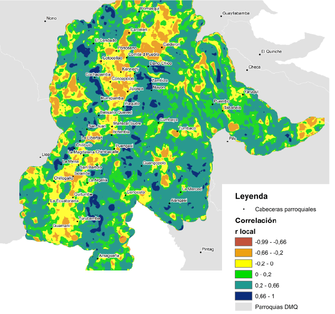
a) Analizar la relación entre la temperatura superficial terrestre (LST) y albedo en el periodo 2020 -2024 para el mes de agosto, y determinar si existe una relación estadística.
b) Determinar si el incremento de temperaturas entre 2020 y 2024 constituye una tendencia-
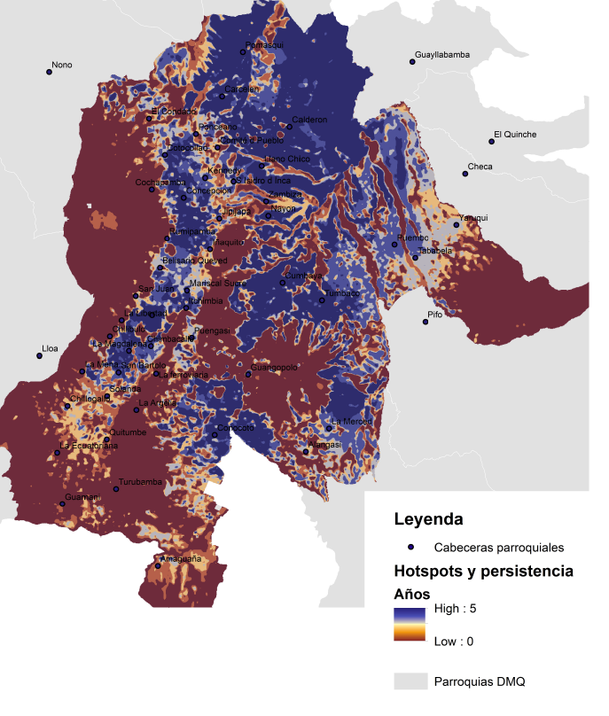
c) Establecer si existe una persistencia espacio-temporal de las islas de calor urbana; todo ello, para conocer dónde y cómo se manifiestan estos comportamientos en territorio, a fin de que las políticas públicas mitigación y adaptación puedan ser más efectivas en términos de priorización en las parroquias urbanas y peri urbanas del DMQ.
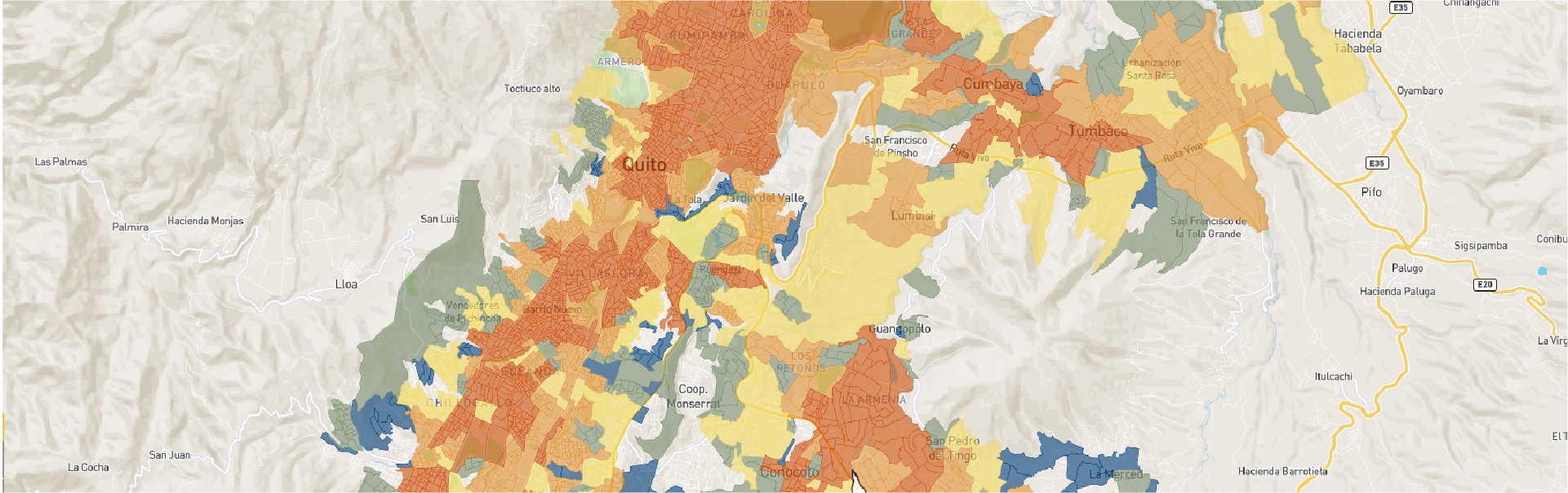
El análisis de LST y albedo muestra que 2024 registró la mayor temperatura superficial (35,3 °C) y 2021 la menor (27,4 °C). No se evidencian tendencias sostenidas, sino incrementos episódicos con variabilidad interanual de 1–2 °C. La correlación LST–albedo revela que en ciertos sectores el albedo mitiga el calor (techos, pavimentos claros, humedad, sombra), mientras que en otros influyen factores como suelos secos, baja vegetación y morfología urbana. El estudio de persistencia identifica hotspots permanentes (4–5 años), intermitentes (3 años) y recientes (1–2 años), cada uno requiriendo políticas diferenciadas en vegetación, materiales de alto albedo, ventilación y regulación térmica.


Investigadores invitados
Paulina Cubillo
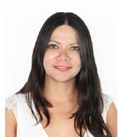
Paulina Cubillo is a Geographic and Environmental Engineer with an extensive academic and professional background. After graduating in 2005, she continued her education through several master's degree programs in areas such as Environmental Management Systems, Geographic Information Systems Development, and Territorial Planning, completing her most recent master's degree in Italy in 2015. She also earned a specialization in Data Science in Costa Rica in 2020. With 18 years of professional experience in Ecuador and Spain, her work focuses on urban planning, territorial management, environmental impact assessment, and data science. She has held positions in both the public and private sectors.
Since 2019, she has served as General Coordinator of the Quito Urban Information Center (CIUQ) of the Pichincha Association of Architects, where she leads research projects in urban planning and territorial management using data science methodologies. She also served as President of the Ecuadorian Association of Geographic Engineers from 2020 to 2022.
In addition to her professional work, she has been a graduate-level lecturer in Urban Studies at Indoamérica University and is a member of the Sectoral Citizen Council for Urban Development and Housing of MIDUVI.

Juan Fernando Vásconez
Juan Fernando Vásconez V. is an Environmental Engineer from the Equinoctial Technological University (Ecuador) and holds a Master’s Degree in Sustainable Urban Technologies from the University of Buenos Aires (Argentina). His research and consulting work focuses on urban sustainability, territorial planning, and climate resilience, with particular emphasis on integrating environmental considerations into public policy and developing instruments for climate change adaptation.
He has led and contributed to internationally recognized projects, including the YAKU pilot project for rainwater harvesting and reuse (recipient of non-reimbursable funding from the IDB Cities Hub) and the initiative Sustainable Strategies for Stormwater Management in the Bicentenario Centrality (winner of the Ecuador Habitat Award 2022–2023). His academic contributions include a publication on participatory urban design in the book Common Spaces, Intermediate Spaces: The Urban Landscape in the Americas.
With more than eight years of professional experience, he combines technical practice with multi-stakeholder participation processes and territorial governance models. A passionate mountaineer, he finds in the relationship between the city and the mountains a constant source of inspiration for advancing adaptation and sustainability projects.

Santiago Bonilla Cáceres
Environmental Engineer graduated from the Central University of Ecuador (FIGEMPA-UCE), with a professional profile focused on data science, applied statistics, and geospatial technologies. His primary research interests center on the development of Artificial Intelligence (AI), Machine Learning (ML), and Deep Learning (DL) models for the analysis of climate-related phenomena, using advanced Geographic Information Systems (GIS) and Remote Sensing tools.
He also possesses a strong background in programming and web development (both frontend and backend), enabling the design and implementation of data analysis platforms and digital tools. His research experience is further supported by his participation as a speaker at academic conferences and his attendance at national and international training programs.
He is a co-author of scientific publications in the fields of applied statistics and environmental chemistry. His profile combines extensive expertise in organic synthesis and materials science, with advanced knowledge of chemical characterization techniques, particularly X-ray diffraction (XRD). In addition, he has a strong foundation in analytical chemistry and chemical processes.
If you have a research project that you would like to showcase on our geoportal, or if you would like to collaborate in the development of a new one, contact us!


Contact
General Inquiries
Documentation
User Support
Sponsored by:
Follow us on social media



Nuñez de Vela N35-204 e Ignacio San María
CP: S170515
Quito - Ecuador
Políticas de privacidad
All rights reserved








Urban Research and Information Center (CIIU)
Architects’ Association of Ecuador – Pichincha Province (CAE-P)